


Published on Feb 14, 2025
Recently, there is an increasing interest in accurate location finding techniques and location based applications for indoor areas. The Global Positioning System (GPS) and wireless enhanced 911(E-911) services also address the issue of location finding. However, these technologies cannot provide accurate indoor geolocation, which has its own independent market and unique technical challenges.
Despite extraordinary advances in global positioning system (GPS) technology, millions of square meters of indoor space are out of reach of GPS satellites. Their signals, originating high above the earth, are not designed to penetrate most construction materials, and no amount of technical wizardry is likely to help. So the greater part of the world's commerce, being conducted indoors, cannot be followed by GPS satellites.
Consider some everyday business challenges. Perpetual physical inventory is needed for manufacturing control, as well as to keep assets from being lost or pilfered. Mobile assets, such as hospital crash carts, need to be on hand in an emergency. Costly and baroque procedures presently track and find manufacturing work-in-process. Nor is the office immune: loss of valuable equipment such as laptop computers has become a serious problem, and locating people in a large office takes time and disrupts other activities.
What these systems share is a need to find and track physical assets and people that are inside buildings. The design differences between an efficient asset-tracking system and GPS arc more basic. First and foremost, control of the situation shifts from users of GPS receivers, querying the system for a fix on their position, to overhead scanners, checking up on the positions of many specially tagged objects and people. In GPS, each receiver must determine its own position in reference to a fixed infrastructure, whereas inside a building, the tracking infrastructure must keep tabs on thousands of tags.
Systems consulting for a health maintenance organization (HMO) sparked the interest in this technology. As patients' files were often impossible to find, doctors were forced to see one in five persons unaided by a medical record. Attempts to bar code the records did not solve the problem, as HMO staff frequently forgot to scan critical files when passing them between offices. Not surprisingly, the files most often misplaced concerned complicated cases with multiple caregivers. The record room employees could be found in clinical areas, most of the time, consulting lists of desperately needed records as they sifted through piles of paper. Several physicians wondered if there was anything like the GPS devices that they could use to track the records through the facility.
Accurate indoor geolocation is an important and novel emerging technology for commercial, public safety and military applications. In commercial applications for residential and nursing homes there is an increasing need for indoor geolocation systems to track people with special needs, the elderly, and children who are away from visual supervision, to locate in-demand portable equipment in hospitals, and to find specific items in warehouses. In public safety and military applications, indoor geolocation systems are needed to track inmates in prisons, and navigating policeman, firefighters and soldiers to complete their missions inside buildings.
These incentives have initiated interest in modeling the radio channel for indoor geolocation, development of new technologies, and emergence of first generation indoor geolocation products. To help the growth of this emerging industry there is a need to develop a scientific framework to lay a foundation for design and performance evaluation of such systems.
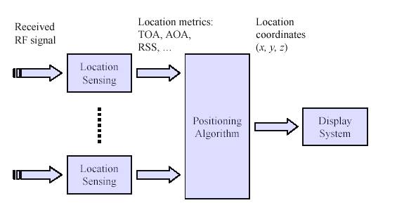
Fig.3.1. Functional block diagram of wireless geolocation
The basic function of a wireless geolocation system is to gather a particular information about the position of a mobile station (MS) and process that information to form a location estimate.
The figure illustrates the functional block diagram of a wireless geolocation system. The main elements of the system are a number of location sensing devices that measure metrics related to the relative position of a mobile station with respect to a known fixed station, a positioning algorithm that processes metrics reported by location sensing terminals to estimate the location coordinates of MS, and a display system that illustrates the location of MS to users. The location metrics may indicate the approximate arrival direction of the signal or the distance between the MS and FS.
The metrics developed for cellular systems are applicable for indoor geolocation systems with special considerations needed for indoor radio channels. just to introduce
AOA Angle Of Arrival
LOS Line of Sight
TOA Time Of Arrival
TDOA Time Differences Of Arrival
RSS Received Signal Strength
The received signal strength (RSS), the angle of arrival (AOA), the time of arrival (TOA) and time difference of arrival (TDOA) of the received signal are the metrics used for the indoor geolocation. As the measurement of the metrics become less reliable, the complexity of the position algorithm increases. The display can simply show the coordinates of MS, or it may identify relative location of MS in the layout of an area. This display system could be software residing in a private PC or mobile locating unit, locally accessible software in a local network area (LAN), or a universally accessible service on the web. As the horizon of accessibility of the information increases, design of the display system becomes more complex.
There are two basic approaches to designing a wireless geolocation system. The first approach is to develop a signaling system and a network infrastructure of location sensors focused primarily on geolocation application. The second approach is to use an existing wireless infrastructure to locate an MS. The advantage of the first approach is that physical specification, and consequently the quality of the location sensing results, is under the control of the designer. The MS can be designed as a small wearable tag or sticker and the density of the sensor infrastructure can be adjusted to the required accuracy of the location finding application. The advantage of the second approach is that it avoids expensive and time-consuming deployment of infrastructure. These systems, however, need to use more intelligent algorithms to compensate for the low accuracy of the measured metrics. Both approaches have their own markets and design work on both approaches has been pursued in the past few years.
| Are you interested in this topic.Then mail to us immediately to get the full report.
email :- contactv2@gmail.com |
